
Vol 3 No 1 | Apr-Jun 2023
Behroopiya
Story by Mohd Salman | Art by Nikhil Gulati
Very little of the world’s landmass today really counts as ‘unexplored’. Spend a little time on the internet (or a library, if you have access to a good one) and you can find out all you need about any place in the world. The terrain, the climate, flora and fauna, people, history… anything you need to know, depending on what you are looking for. There is a vast network of people, machines, satellites, cameras and equipment working all the time to make sense of the world.
Not so long ago, however, so much of what we know lies on the map was mere conjecture. Large tracts of land on maps were simply blank, because they were either uninhabited, inhospitable or simply because the rulers of those areas did not allow people from other countries to move through their territory unchecked.
The Great Trigonometrical Survey
In 1802, the British began the process of surveying India with scientific precision. Led by Major William Lambton, the Great Trigonometrical Survey began on April 10, 1802, in the then newly-colonised territory of Mysore. From an initial plan of five years, it took the survey about seven decades to triangulate the entire subcontinent.
To learn more about the Survey and its origins, watch here:
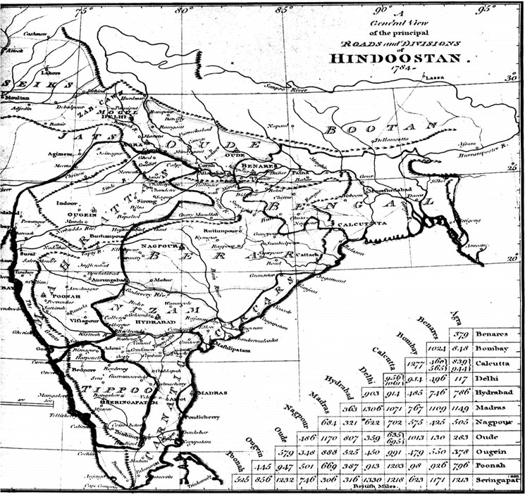
A map of India in 1784, with inaccuracies rectified by the Great Trigonometrical Survey
The Great Game
In the early 1800s, a struggle ensued between the British and Russian Empires over the control of Afghanistan and a number of countries in its vicinity, a strategic political campaign that came to be known as the Great Game. The Game was played out through a series of wars dotted across the continent, and a near-unbroken spell of espionage. It resulted in the British consolidating their power over the subcontinent, while Russia gained control of several countries in Central Asia.
Cartographical and demographic surveys were central to the politics of the Great Game. Apart from contributing to our knowledge of the world, they also helped identify regions rich in natural resources, as well as trade routes. Rudyard Kipling’s novel Kim romanticised and immortalised the idea of the Great Game for generations of readers.
Here is a short history of the Great Game:
Nain Singh: A diminutive man who cast a great shadow
Nain Singh was the son of a trader who came to play a major role in the surveying of the Himalayan regions of Indian and Tibet. Over the course of his surveys, Nain Singh walked thousands of kilometres in precisely calculated paces, with none of the tools of measurement we now take for granted. This was a man who walked the Roof of the World, bringing one of the most obscure parts of the planet into the light.
Click on the links below to learn about Nain Singh’s life story:
https://www.himalayanclub.org/hj/72/2/pundit-nain-singh-rawat-explorer-extraordinaire/
On the occasion of Nain Singh’s 187th birth anniversary on October 21, 2017, Google honoured him with a Doodle:
https://www.google.com/doodles/nain-singh-rawats-187th-birthday
